Saturday, November 14, 2009

Marshall Plane Crash Site, Wayne County, WV


Marker Text: On Nov. 14, 1970, 75 people died in the worst sports-related air tragedy in U.S. history, when a Southern Airways DC-9 crashed into the hillside nearby. The victims included 36 Marshall University football players, 9 coaches and administrators, 25 fans and air crew of 5. No one survived this horrific disaster.

Location: Old Route 75, Kenova near the airport, road is a dead end road near the end of the airport runway.

   One begins to think one is getting old when you come across an historical road marker about an event in history you can actually remember, but the Marshall Plane Crash is a one of those unfortunate, but historically significant events. I was a college sophomore when the plane crash occurred and it shocked all college sports teams across the country. Then, while I was living in West Virginia south of Huntington, WV is when they made the movie “We Are Marshall” which recalled the events at the time of the accident and the events at the University in attempting to rebuild their football program.
   A chartered jet airliner carrying the Marshall University football team, coaches and a number of prominent Huntington residents crashed in flames on its approach to Tri-State Airport Saturday evening on Nov. 14, 1970. There were no survivors.
   Southern Airways of Atlanta, Ga., said its two-engine DC-9 was carrying 70 passengers and five crewmen. The plane was returning the Marshall football players, most of the coaching staff and a group of supporters from Greenville, N. C., where East Carolina University defeated the Marshall team Saturday afternoon.
   The crash occurred about 7:45 p. m. less than a mile west of Tri-State Airport. Weather conditions were poor and light rain was falling.
   The Herald-Advertiser's Jack Hardin, the first reporter at the scene some 250 yards east of WV Route 75 south of Kenova, said:
   "There's nothing here but charred bodies. It's terrible." Bodies and wreckage were scattered over a wide area. Gov. Arch A. Moore Jr. and Dr. Donald N. Dedmon, Marshall's acting president, rushed to the scene.

   Hardin reported a piece of the plane was found on a hillside about a half-mile from the principal crash site. He said sections of bodies also were reported found there, too. Searchers were combing the hillside early this morning with the aid of flares.
   At 12:10 a. m., the first bodies were placed on National Guard trucks. They were being taken to the National Guard Armory at the airport, where a temporary morgue was established. Hardin said recovery crews were running short of bags to hold the bodies.
   The tragedy was the worst domestic air crash during 1970 and it was described by the FAA as one of the worst in history involving an athletic team.  The crash also was the worst in West Virginia air travel history.
   Less than two months earlier, on October 3, one of two chartered planes carrying the Wichita University football team, coaches, boosters and others, crashed in the mountains of Colorado, killing 31 persons, including 13 football players.  The Marshall crash was the second fatal crash at same the airport in 16 days. Three Army officers were killed in the crash of a military plane Oct. 29. A fourth passenger, critically injured, survived. In the earlier crash, the airplane hit a hill 2,700 feet short of the runway, after apparently losing power in one of its two engines.
   This year marks the 39th anniversary of the plane crash that took the lives of 75 members of the Marshall University football team, coaches, staff, community members, and crew. This year, as the University does every year since the tragedy, Marshall's Student Government Association will conduct a memorial service at the memorial fountain which commemorates the tragedy on the campus of Marshall University. The fountain is silenced each Nov. 14 during the annual memorial service honoring the victims of the 1970 Marshall plane crash and remains silent until spring.
   In an interesting personal historical note about Marshall University and the events to rebuild the football program. In a January 10, 2007 article in the Huntington Herald-Dispatch about the movie, “We Are Marshall.” In the movie, they stated that the first coach hired by Marshall to replace Head Coach Rick Tolley who was killed in the plane crash, was not Jack Lengyel but Dick Bestwick, assistant coach at Georgia Tech, he changed his mind after two days and returned to Georgia Tech. What I found interesting about this fact is that Dick Bestwick had been the head football coach during the early 60's at the high school where I graduated in Pennsylvania before he went on to Georgia Tech.
   For more information about the plane crash, visit the WV Historical Site.

Friday, November 13, 2009

Neshannock Potato, Lawrence County, PA


Marker Text: The once widely-known and choice variety originated just west of here , on a farm occupied by John Gilkey, 1798-1826. A brother, James, was fellow-worker. Their potato was also called Mercer or Gilkey.


Location: US 19 at SR 1004 (Shaw Rd.) just S of Mercer County line, New Wilmington. Dedication Date: March 19, 1948

   What is fascinating about historical road markers is that they cover a variety of topics, from people, places and things to even vegetables. In 1797, Irish immigrant John Gilkey settled in Lawrence County, Pennsylvania and cultivated the Neshannock Potato, a new variety of potato achieved wide popularity in the nineteenth century. Like apples, potatoes were critical to the survival of farmers and their families. Spuds kept well over the winter months and were vitamin packed. They also figured prominently in crop rotation schemes and were used as animal feed for cattle and pigs.
   Settling on a farm in present-day Washington Township, Lawrence County, Gilkey planted three different varieties of potatoes - blue, red, and white. Within a few years of his arrival, these three varieties had cross-pollinated. When Gilkey planted the seed potatoes he collected they produced a new type of potato that he named "Neshannock," after a nearby creek. The Neshannock was a large and long potato, reddish purple in color, with streaks of the same color through the flesh that generally disappeared after the potato was cooked.
   Gilkey and his brother gave seed potatoes to friends and neighbors. Soon farmers in nearby counties also were growing them, for they quickly found that the Neshannock was more productive than older varieties, and of good quality in flavor and size.

   In the decades that followed, cultivation of the new potato spread quickly to farmers in the Middle Atlantic states, and then across the country. In the 1830s, a farmer named Titus Bronson introduced them to Michigan and claimed that he raised 700 bushels on a single acre of ground on his farm near present-day Kalamazoo. By the 1870s, farmers in Idaho and Utah also were raising them and shipping them by rail to California.
   By then the Neshannock was being marketed as the Gilkey, Mercer, Neshannock, Shannock, or the Shenango. Multiple names might have been confusing to some, but farmers and consumers alike were able to recognize the Neshannock by its distinctive features. In 1843, the highly respected farmer's journal The Cultivator stated that this spud was "one of the most valuable of table potatoes, white, mealy and of good flavor." In the nineteenth century, the Neshannock became the standard commercial potato in the United States. A very productive and an excellent all-purpose potato, it was prized for its size, wonderful flavor, and ability to keep.
   With the introduction of new, more productive varieties in the late nineteenth century, the Neshannock gradually fell out of favor. But for much of the 1800s, Pennsylvania's Neshannock potato helped to feed the nation.

Monday, November 2, 2009

John William Heisman (1869-1936) Crawford Co., PA


Marker Text: Renowned college football coach and name-sake for the sport’s highest amateur honor, the Heisman Memorial Trophy. His innovations included legalizing the forward pass, the center snap, the scoreboard, and game quarters. Heisman promoted player safety by advocating gear improvements and rule revisions. A founder of the American Football Coaches Association, he grew up in Titusville and played football near his father’s local oil cooperage.

Dedicated: Friday, August 28, 2009 Erected by the Pennsylvania Historical and Museum Commission.

Location: Next to the Titusville High School, Carter's Field, at the intersection of Central Ave. and Brown St. in Titusville, PA.

   This is a new marker erected this year as part of the 150 year anniversary of Drake's Well located along North Central street next to the high school football field in Titusville, PA. When we think of Titusville, generally people think of the discovery of modern oil drilling by Edwin Drake. Oil production in this area of Pennsylvania around Titusville had an impact in a number of different ways resulting from oil production. One example were the families that moved to Titusville as a result of oil, such as, Michael Heisman who moved his family from Cleveland. His trade as a cooper brought him to built wooden oil barrels used to move the oil that brought wealth and prosperity to the region.
   His son, John William Heisman was raised and attended schools in Titusville, graduating from Titusville High School in 1887 as a baseball player, football player, and star gymnast on his squad. Born Johann Wilhelm Heisman on October 23, 1869, in Cleveland, Ohio, he was the son of John M. Heisman and Sara Lehr. The name John William was later adopted in order to make less apparent the fact that he was the son of immigrants. He learned to play football in Titusville and went on to become one of the greatest collegiate football coaches. Each December, America waits to hear who will receive the Heisman Memorial Trophy, one of the most coveted awards in sports.

   John Heisman entered Brown University where he gave up other activities to pursue the sport of football as a lineman. Due to Brown’s lack of funding, football was relegated to a club sport unworthy of intercollegiate competition. This setback led to Heisman’s transfer to the University of Pennsylvania where he played for two more years and graduated with a degree in law.

   Heisman decided to not pursue a law career, but accepted an offer to coach football at Oberlin College. Football at the time of Heisman was quite different than the football we think of today, while coach, Heisman also played defensive end on his own football team, a practice that is no longer legal in collegiate sports. Heisman went on to coach at Buchtel College (now the University of Akron), Alabama Polytechnic Institute (now Auburn University), Clemson University and eventually to Georgia Tech where he had his longest tenure as a coach. He coached football at eight different colleges and universities between 1892 and 1927.
   During his time at Georgia Tech, Heisman was at the frontline of many changes in the sport. In 1906, the forward pass was legalized, a cause for which Heisman had lobbied for since 1900. In 1908 and 1910, he was named the director of the Atlanta Athletic Association and the president of the Atlanta Baseball Association, respectively. In 1910, he helped champion the change of football game timing from a two half model to its present four quarter setup.
   After 16 years, Heisman ended his tenure at Georgia Tech due to his divorce. He returned as a coach for the University of Pennsylvania. In 1922, Heisman authored his only book, Principles of Football. Written as a reference text for football players, the book contains many blank pages for note taking throughout the chapters. He was named president of the American Football Coaches Association for two consecutive terms while coaching at Washington and Jefferson in Washington, Pennsylvania and Rice University.
   Heisman remarried in 1924 and three years later resigned as Rice's coach. The couple moved to New York City where he authored a sports column for Collier’s magazine and became the director of the New York Downtown Athletic Club (DAC).
   As director of the DAC, John traveled to Chicago and Detroit to research other successful athletic organizations. His research led to the founding of the DAC’s Touchdown Club. This group began offering a trophy for the best college football player in the Eastern states. By 1935, the award had become national.
   John Heisman died after suffering from a short illness in 1936. When the DAC gave their second trophy two months after his death, it was renamed the Heisman Memorial Trophy, which it remains today. He died in New York City, but was buried in his wife’s hometown of Rhinelander, Wisconsin

Thursday, October 29, 2009

Duck Run Suspension Bridge, Gilmer County, WV


Marker Text: 1922-1992. Funds raised and labor provided by Duck Run & Bear Run citizens Summers, Keith, Bush, Floyd Langford, Hess, Hardman, Divers, Simmons, Clovis, Wilfong, Wright. Engineers: Fred Lewis & Wm Moss. Wire cables and steel came from Roebling Co. & Bethlehem Steel. Deck lumber & concrete for towers, locals. Span 350 ft, 7 in; width 11’ 6 . Placed on National Register in 1997.

Location: On WV Route 5, near junction with County Route 30, near the town of Trubada, three miles east of Glenville, WV.

Erected by the Gilmer Co. Historical Society and West Virginia Division of Archives and History in 2000.

   The bridge served the community for 70 years, being completed in 1922 and closed in 1992. Before its construction, you had to cross the river by driving through the water of the river from one bank to the next. These were called river fords, “fords” were these types of crossings and is seen on many markers particularly as they relate to the Civil War. You can still encounter these roads in rural sections of West Virginia today. Following World War 1, there was an attempt to improve the nation's roads in the “National Good Roads Movement,” the first national attempt to provide paved all weather roads in rural areas.

   What makes this bridge interesting this the fact that its construction was supported by the local residents raising money through yard sales, cake walks, raffles, etc and the construction through supported by two county engineers was provided by local volunteers. I am confident that this is not the only rural bridge constructed this way, but it is the first one I have encountered. It is my understanding that similar bridges once existed throughout West Virginia crossing the states many rivers. Other bridges have since been replaced and removed. I would guess that this bridge remained because of its remote location and the fact that the replacement bridge was constructed upstream and it was not necessary to remove the older bridge for its construction.
   The Duck Run Cable Suspension Bridge (also called the Trubada Swing Bridge) spans the Little Kanawha River between WV Routes 5 and 30, used to connect these two roads. The bridge was replaced in 1992 by a new concrete bridge about 500 feet upstream of the suspension bridge.
   The overall length of the bridge is 350 feet 7 inches with the center span being 209 feet 9 inches. The two wire cables are supported by four reinforced concrete towers, two on each bank of the river.
   The wire rope and all the fittings when the bridge was built were readily available from wire rope dealers. Wire rope at the time was developed for a wide variety of industrial uses and was available from companies such as Roebling and Bethlehem Steel. The timber bridge deck consists of 4 inch by 8 inch wooden planks laid flat and supported by pairs of 3 inch by 12 inch wood floor beams, 14 feet 1 inch long. These pairs of beams are in turn supported by vertical wire rope suspenders. The curb width is 10 feet, 9 inches while the overall deck width is 11 feet 6 inches. The timber for the bridge was obtained locally and the concrete for the towers was made on-site. Originally the bridge had no railings, but were added later. According to documents in 1997, there were plans to develop a recreational area around the bridge and open it for pedestrians, when I was taking these photos in 2008, there was some movement in that direction but not really well developed. The bridge seems in good condition despite its age and lack of maintenance.


Thursday, October 22, 2009

Jamestown Ferry


Surry County, VA
Marker No. K-301


Marker Text: Near this site on February 26, 1925, the ferry Captain John Smith began the first automobile ferry service crossing the James River. Captain Albert F. Jester was the inaugurator and owner/operator until it was sold to the Commonwealth of Virginia in 1945. This ferry system provided an important link for the Maine-to-Florida traveler through Surry County to Jamestown Island, the site of the first permanent English settlement in America.

Location: On Route 31 at ferry south entry in Scotland.  Erected by the Department of Conservation and Historic Resources in 1987.

Photo (at right) taken looking at entrance to Jamestown Ferry from south side of James River in Surry County.
  
  What I find most interesting about his marker are my early teenage memories of traveling on this ferry in the mid 1960's, it was the first time I ever rode on a ferry. The actual ferry boats have changed considerably since I traveled on them in 1960's. We were on a family vacation returning from Myrtle Beach, South Carolina and my parents were going to take my two sisters and myself to Jamestown Island and we crossed the James River on the ferry. My wife and I crossed it again in the summer of 2008, when I took these photos.
Photo on the left was taken from ferry looking at Jamestown Island.

   The Jamestown Ferry is the only vehicle crossing between the James River Bridge in Newport News to the east and the Benjamin Harrison Memorial Bridge up river to the west near Hopewell. The ferry serves as the river crossing for State Route 31. The ferry connects Jamestown, James City County to the north with Scotland Wharf in Surry County to the south.

   The ferry at the time I crossed operated 24 hours a day, seven days a week and was toll-free. You will need to prepare yourself for a random security screening and identity check before you drive unto the ferry, but on my visit this was no inconvenience at all and actually quite comforting to know that they take security of travelers seriously.

   If you plan to visit Jamestown Island, a trip across the ferry particularly going north gives you a unique view of Jamestown Island from the river and the trip across takes 15 minutes giving you the opportunity to get out of your vehicle and take photos. On the Jamestown side you will be able to see replicas of Christopher Newport's three tiny ships, Susan Constant, Godspeed, and Discovery which are docked at Virginia's Jamestown Settlement attraction. Seeing these ships up close at the Jamestown settlement gives you an appreciation of just how courageous those first individuals truly were who came to the new settlement on Jamestown Island in 1607.

   As you depart from the ferry on the northern shore you can easily visit Jamestown Island, Virginia's Jamestown Settlement and enter the southern end of the Colonial Parkway, which will take you to Colonial Williamsburg and Yorktown.

   One might ask why there is still a ferry here and not a bridge, not that a bridge has not been considered over the years. One, of many factors considered, is the cost of building a bridge over a navigable waterway which is substantial. If built as a toll bridge the fees would probably deter its use due to the tolls needed to recover the high construction costs. Another important factor in favor of a ferry, over a bridge would be the historic impact a bridge would have in this very historic area of Virginia. Jamestown is the first permanent English Settlement in America over 400 years ago and the construction of a bridge at this location would greatly impact the historic environment of the area.
 
  The presence of a ferry though modern at this point preserves the historic appearance of the area while reminding people that at one time ferries were the principle means for a long time in our history for crossing large rivers throughout Virginia and the other colonial states. There are numerous historic markers in Virginia, particularly along the James River, which describe these once present ferries. They remind us of the presence of long past ferries that dotted the country crossing our rivers at some time over the course of our history. It is good that the Virginia Department of Transportation (VDOT) continues to operate and maintain this ferry crossing for the enjoyment of all the travelers that come to this historic region of Virginia.

Wednesday, October 21, 2009

Flight of Richard C. duPont, Nelson County, VA


Marker No. W-219

Marker Text: Near this site on September 21, 1933, Richard C. duPont was launched from Afton Mountain in his Bowlus sailplane, Albatross. Four hours and fifty minutes later he landed at Frederick, Maryland, establishing a United States distance record for sail planing of 121.6 miles, almost double the previous U.S. Record of 66 miles.

Location: On Interstate 64 eastbound lanes, on Afton Mountain, at first scenic overlook about 1,500 feet east of the exit for Route 250 and the Skyline Drive. This marker is located next to marker W-218 (Rockfish Gap Meeting)
Erected by the Virginia Historic Landmarks Commission in 1983.

   Richard Chichester duPont was a member of the prominent Delaware duPont family. Born in 1911 to Alexis F. duPont and Mary Chichester, his father was the vice-president of the E. I. du Pont de Nemours & Co. Richard developed an interest in aviation at an early age.
   He started piloting gliders in 1929. By this time he had already logged some 1,000 hours as an airplane pilot. He learned skills for flying gliders through the Soaring Society of America at Elmira, N.Y. While at the University of Virginia (only about 20 miles from this marker) he founded a campus soaring club. He studied aviation in 1932 at Curtiss-Wright Technical Institute while in the same year with his sister, Alice flew a open-cockpit airplane up the Amazon River.

   Following a soaring meet in Elmira, N.Y. Richard du Pont was discouraged by few days of favorable winds for soaring and he and others thought there had to be other soaring sites in the eastern U.S. He had been studying maps and he was certain the Shenandoah Valley of Virginia offered an ideal solution for an alternative soaring site. To test his theory Dick duPont invited other pilots to an informal meet centering at the Swannanoa Country Club near Waynesboro, atop the Blue Ridge in western Virginia. On September 20, 1933, Emerson Mehlhose of Wyandotte, Michigan took off from Rockfish Gap in a wind that nearly tore his wings off, soared up the Shenandoah Valley 71 mi. for a new U. S. distance record. (Old record: 66.7 mi., by Martin Schempp, from Elmira, N.Y..) Richard duPont on the next day started on Afton Mountain at Rockfish Gap, he passed Mehlhose's landing place, kept on soaring, crossed the Maryland line, started to head into Pennsylvania when rain and fog forced him back to Frederick, MD, a distance of 121.6 mi. — 14 mi. short of the world record.

   The sailplane that Richard duPont used on his record breaking flight was his Bowlus sailplane, Albatross. This sailplane was designed and built by William Hawley Bowlus who was quite well known as a sailplane designer from San Fernando, California. Mr. Bowlus was the Superintendent of Construction on Charles Lindbergh's aircraft, the Spirit of St. Louis. He also gave gliding lessons to both Charles and Anne Lindbergh. William Hawley Bowlus is probably better widely known in non-aviation circles for his key role in the design of Airstream travel trailers.
   Richard with his brother, Felix established All American Aviation Company an airmail service eventually covering parts of Pennsylvania, West Virginia, Kentucky and Ohio. Six years after Richard's death, the air service began passenger service and become Allegheny Airlines, which was the precursor to today's US Airways. I remember the old Allegheny Airline planes on trips to the old Pittsburgh airport. These were the days prior to airport security where you went through the gate walked across the tarmac, up the stairs into the plane, generally all outside regardless of the weather.
   During World War II, the U.S. established the American Guilder Program. Richard duPont was special assistant to General “Hap” Arnold and placed in charge of the glider program after the death of director Lewin B. Barringer. During a demonstration flight on September 11, 1943 at March Air Field in California, duPont and other passengers were killed in a MC-1 glider. William H. Bowlus who was also a passenger managed to parachute out to safety before the glider crashed.
   Richard's brother, Major Felix duPont succeeded him in the glider program. This marker is in the approximate area for the start of his flight in 1933 and is close to the southern entrance to the Skyline Drive.
   Both Richard C. duPont and William H. Bowlus were inducted in the Soaring Hall of Fame in Elmira, N.Y.

Monday, October 19, 2009

Letitia Christian Tyler, New Kent County, VA


Marker No. W-39

Marker Text: Letitia Christian Tyler, wife of President John Tyler, is buried at Cedar Grove Cemetery a mile northeast. Born on 12 November 1790, a daughter of Robert and Mary Browne Christian, she married John Tyler at her home, Cedar Grove, on 29 March 1813. Her husband served as a congressman (1817-1821), governor of Virginia (1825-1827), senator (1827-1836), vice president (1841), and tenth president of the United States (1841-1845). Letitia Christian Tyler was the first First Lady to die in the White House when she succumbed on 10 September 1842 after a series of paralyzing strokes. Her body lay in state in the East Room of the White House, then was transported to her family home at Cedar Grove for interment.
Location: On Route 60 on the east bound lane near intersection with Route 106, 4.9 miles southeast of Bottom's Bridge. Grouped with marker W-18 (Long Bridge).
Erected in 1994 by the Department of Historic Resources.
Photo taken looking east on Route 60 toward intersection with Route 106.

   Until I came across this marker, I was unaware that any First Lady had died while residing in the White House. Actually, it never occurred to me that a First Lady of the U.S. might have died while in the White House. In fact, three first ladies have died during their husbands terms in the White House. As a sort of an ironic twist, her husband John Tyler became the first vice-president to become president of the U.S. after the death of William Henry Harrison who was the first president to die in office.
   Mrs. Tyler had already become an invalid confined to her chair for two years before her husband became president.
   Photo on left is the Cedar Grove Cemetery with the home in the background.
   Mrs. Tyler was born and raised in the country side surrounding this marker in New Kent County, Virginia. As many women of her era, she was instructed in the duties of a wife and mother, learning skills of managing a plantation, rearing a family and presiding over a home. During the political years of John Tyler, prior to his becoming president, she only once joined him in Washington for the winter social season, choosing mostly to remain in her home in Virginia, where she was most comfortable with her Bible, prayer book and knitting by her side. After John Tyler became vice-president he thought he could spend most of his time at their home in Virginia, since the duties of a vice-president were non-demanding at the time, but this lasted only one month before becoming president.
   Mrs. Tyler had eight children of which seven survived.
   Mrs. Tyler's daughter-in-law, Priscilla Cooper Tyler, described her as "the most entirely unselfish person you can imagine... Notwithstanding her very delicate health, mother attends to and regulates all the household affairs and all so quietly that you can't tell when she does it."
   While residing in the White House, Letitia Tyler continued her role, as her health permitted, to manage the household affairs of the family at the White House, mostly from a second floor room. Due to her health she did not attempt to maintain management of the White House social affairs. Official White House affairs, normally performed by an early 19th century First Lady were assumed by her daughter-in-law, Priscilla Cooper Tyler. Mrs. Tyler's only White House appearance at a social function was the White House wedding of her daughter, Elizabeth in 1842 on February 7, 1842. Mrs. Tyler died later that same year in September.
   The cover stone over Mrs. Tyler's grave reads: “All that is mortal of Lettitia Tyler, Wife of John Tyler, President of the United States, Lies underneath this marble, She departed this life, 10 Sep. 1842 at the President's House in the City of Washington in the 52nd Year of her age. Her life was an illustration of the Christian Virtues and her death the death of the righteous.” The Cedar Grove Cemetery is one mile north of this marker on Route 106, on the left while traveling north, sign for cemetery is difficult to see.
   For a more detailed description of Mrs. Tyler's life go to Biographies of First Ladies.
   You were probably wondering who the other two first ladies were who died in the White House: Caroline Harrison (1892), wife of Benjamin Harrison and Ellen Wilson (1914), wife of Woodrow Wilson.

Friday, October 16, 2009

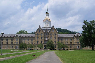
Weston State Hospital, Lewis Co., WV


Marker Text (No. 1): The oldest State Institution in West Virginia was authorized by an act of General Assembly of Virginia, March 22, 1858. The War Between the States delayed the construction. It was not opened for patients until October 22, 1864.

Location:  US 33 and US 119, west corner of hospital lot.

Marker Text (No. 2): Authorized as a western asylum by the state of Virginia in 1858. Construction was started in 1860, completed by the new State, and opened in 1864 as a hospital for mentally ill. This is the largest hand-cut stone building in America.

Location: US 33 and US 119, going SW out of Weston on east corner of hospital lot.

Today's entry deals with two markers about the same subject, Weston State Hospital in Weston, West Virginia. These two markers are on opposite corners on Route 33/119 next to the old hospital. I ran across these markers and the old hospital by accident one day while traveling through Weston looking for another marker.
   Before I knew anything about this old state mental hospital, I found that standing next to it to take these photos was a creepy and disturbing experience. Later, when I heard that the old building may be haunted, I did not find that assumption to be unrealistic.
   Prior to the American Civil War, there were two institutions in Virginia to treat mental illness. Overcrowded facilities at Williamsburg and Staunton often meant that those in need of treatment were confined in jails. Western Virginia politicians demanded a new facility be built west of the Allegheny Mountains. Virginia had never funded a public institution in present-day West Virginia, a point of contention among those who leaned toward forming a new state. To appease western leaders, the Virginia General Assembly authorized the establishment of the Trans-Allegheny Lunatic Asylum in 1858, although funds were not appropriated until January 6, 1860. The Civil War delayed construction and the facility finally opened in October 1864 as the West Virginia Hospital for the Insane, later renamed Weston State Hospital.

   Weston State Hospital was constructed between 1858 and 1881, is believed to be the largest hand-cut stone masonry building in North America, and is purportedly the second largest in the world, next to the Kremlin. The main building is massive, built of sandstone blocks in its exterior walls and was designed by Richard Snowden Andrews, a Baltimore architect whose commissions included the custom house in Baltimore, the governor’s mansion in Annapolis, and the south wing of the U.S. Treasury building in Washington, D.C. The building measures nearly 1,300 feet and the center unit is four stories high with a great cupola and clock tower. This center section originally was intended for business offices and personnel and even at one time had a large ballroom.

   The state closed the facility in 1994 and it sat empty for many years. It was designated for demolition when it was purchased by private individuals who wished to preserve the building. They chose to maintain the original name for the facility, “The Trans-Allegheny Lunatic Asylum”.
   Ghost Hunters from the SyFy Channel have visited the Weston Hospital and conducted investigations regarding the hospital being haunted. The episode which covered their visit is from Season 4 and is called, “Haunted Asylum.” A short overview of the investigation can be found on their web site. If you fancy yourself an amateur ghost hunter, it is my understanding that you can arrange to spend the night at the hospital to conduct your own investigation.

   By the 1960s, these institutions had become overcrowded and underfunded, West Virginia like many states developed community-based mental health programs. People formerly committed to state hospitals could now receive services in their own communities. As local services expanded, state institutions downsized or closed. Weston State Hospital closed in 1994 and was replaced by a much smaller facility named for State Senator William R. Sharpe, Jr. I had the opportunity to meet State Senator Sharpe in 2003 and then again in 2005 when he introduced me to the WV State Senate, when I was invited to give the opening prayer for the first day of the legislative session by Senate President Earl Ray Tomblin.

Thursday, October 15, 2009

William E. Carson


Warren County, VA
Marker No. JD-2

Marker Text: William E. Carson, of Riverton, was the first chairman of the Virginia Conservation Commission, 1926-34. As such he was a pioneer and leading spirit in the establishment of the Shenandoah National Park and Skyline Drive; the Colonial National Historical Park; the state parks, and the state system of historical markers.

Location: On Route 340 in the southbound lane, south of Front Royal just south of the northern entrance to the Skyline Drive, Shenandoah National Park.  Erected by the Virginia Conservation Commission in 1941.

   When discussing the topic of historic road markers, specifically in Virginia, it seems appropriate to have a road marker about the person of William E. Carson. Carson was the principal state official to bring about the creation of the state system of historical road markers, that dot the countryside in Virginia. This was one among his many accomplishments.
   William Carson was a native of Ireland born on October 8, 1870. His parents moved to Riverton, Virginia which is located just north of Front Royal, Virginia along the north and south forks of the Shenandoah River. His father, Samuel would establish the Riverton Lime and Stone Company, which William Carson would eventually take over from his father.
   Photo (on left) taken looking north on Route 340 toward Front Royal, entrance to Skyline Drive is in the background to the right in the northbound lane of the highway.

   He entered the area of politics in 1910 and served for thirty years as chairman of Virginia's Seventh Congressional District's Democratic Committee. In 1925, he successfully managed the election of Harry Flood Byrd as Virginia's governor. Governor Byrd appointed Carson as chairman of the newly created Virginia Conservation and Development Commission. He held this position from 1926 to 1934.
   During this time Carson made major contributions within Virginia that endure today. From accounts, I have read, he did all this work as chairman without collecting any salary.
   When he died in 1942, the Richmond Times-Dispatch wrote:

“It can truly be said that no man now living has done more for this State, or has labored more unselfishly, or has left a deeper and more lasting impression upon the public life of Virginia during his time, than this quiet and forceful business man who was called from the relative obscurity of his private interests to serve the State in a capacity fraught with difficulties and demanding the high qualities of genius and statesmanship.  How well that task was performed is now a matter of history.”

   During and prior to these years as chairman of the Conservation and Development Commission, Carson was a leading advocate of establishing a national park along the Blue Ridge mountains of Virginia, which today is the Shenandoah National Park containing the Skyline Drive. He assisted in getting Congress in May, 1926 to authorize the creation of the park, though state and private funds would be needed to buy the land before the federal government would take over the newly created park. The creation of the park was no easy task and for eight years Carson showed considerable political skills in adapting to the changing economic situation, in order to make the park a reality.
   Carson believed that the best way to win support for the Shenandoah National Park was to persuade the U.S. president that the area’s scenery and rustic beauty made it an ideal site for a presidential retreat.  Carson had lobbied Calvin Coolidge on situating a camp in the park, but to no avail.  Herbert Hoover, an avid fisherman, expressed interest in the idea, after Carson told Hoover of the excellent trout fishing in the area. Hoover chose the site for his camp, which can still be seen today by those visiting the park. Hoover's involvement served to revive interest in building a road through the park, a “skyline drive” which the Southern Appalachian Mountains Commission had envisioned in 1924 when it recommended the Blue Ridge for the national park. In 1930, Hoover backed a bill which allowed for the use of drought relief funds to build the first twelve-mile stretch of Skyline Drive.
   In this role as chairman of the Virginia Conservation and Development Commission, he influenced many state projects, such as, establishing the state park system, establishing the Colonial National Historic Monument linking Yorktown, Williamsburg, and Jamestown, which included the Colonial Parkway. He reorganized the state forestry and geological departments and helped form the Virginia State Historical Department; and, of course, he helped to develop the Virginia system of highway historical markers of which many of these markers from this period (1926-1934), still can be found along Virginia's roadways. This marker was erected and installed one year prior to Carson's death in 1942, which is unusual for a marker to be erected for a living person.

Tuesday, October 13, 2009

Bigler Graves, Mercer Co., PA


Marker Text: Jacob and Susan Bigler, parents of two governors, are buried here. Their son William was Governor of Pennsylvania, 1852-55; and their son John, Governor of California, 1852-56.

Location: On PA Route 58, Southeast of Greenville, PA.
Erected by the Pennsylvania Historical and Museum Commission in 1946. Dedicated on 11/12/1946

   One reason that I began my interest in historical road markers was the rich history and amazing facts that often lie below the surface of the information found on these markers. Frequently, a person will discover another fascinating story within another. A case in point is the Bigler Graves marker located on PA Route 58 in Mercer Co., Pennsylvania just south of Greenville. Countless people drive by this marker without noticing the simple historical information on this marker. Nowadays people are not too much interested in the simple graves of a seemingly obscure couple. This marker is located in front of an old cemetery dating back to the early years of Mercer Co. PA.

   Jacob Bigler moved his large family to Mercer County about 1822 and five years later died leaving his wife, Susan with ten children to support alone. Susan Bigler lived until 1854 and at the time of her death her son William was governor of Pennsylvania and another son, John was governor of California.
   When Mrs. Bigler died her obituary stated, “She was a strict member of the Presbyterian Church, and died in the fullest confidence of the Christian...” When, “Mr. Bigler died, leaving her in that wild unsettled region, with ten children dependent upon her alone for support. She maintained them all, maintained them in knowledge, and impressed upon their minds lessons usefulness to guide them safely and with honor through subsequent life. During the 28 years of her widowhood, she resided upon the same old farm, about nine miles from Mercer, on which she died.”
   Susan Bigler's son William moved to Clearfield, PA and made his fortune in the timber business and from 1841 to 1847 served in the Pennsylvania State Senate. In 1851 he was elected Governor of Pennsylvania and served from Jan. 20, 1852 until Jan. 16, 1855. He later was elected to serve as Pennsylvania's U.S. Senator from 1856 to 1861. He worked with others during these years attempting to develop a compromise with the southern states in hopes of avoiding the coming Civil War. After his political life, he became the president of the Philadelphia and Erie Railroad.

   William's older brother, John Bigler decided to go west during California's gold rush by driving an ox team west. John Bigler became know for his bravery in aiding the sick and burying the dead in Sacramento during a cholera epidemic, though it nearly killed him. John Bigler served as California's Third Governor from 1852-1856 and was the first governor to successfully complete an entire term and the first to win re-election. A couple of legends are connected with Governor Bigler. In 1852, State Senator James W. Denver and U.S. Representative and Alta California publisher Edward C. Gilbert rowed out to Angel Island to settle a dispute over Gilbert's attacks against Governor John Bigler on the field of honor. Only Denver returned alive. Also, while governor in 1854, it is said that Bigler rescued the portrait of George Washington from the Senate Chamber during a fire, the portrait still hangs in the Senate Chambers, today. The 1854, California legislature honored Governor Bigler by naming the state's largest lake after him. In 1870, Bigler Lake was renamed “Lake Tahoe.”

Saturday, October 10, 2009

James Edward Hanger


Augusta County, VA
Marker No. W-156


Marker Text: Born near Churchville on 25 Feb. 1843, Hanger joined the Churchville Cavalry at Phillipi, W.Va., on 2 June 1861, where the next morning he was wounded. The resulting amputation of his leg was probably the first of the Civil War. He convalesced at his parents' house, which stood nearby. Within three months he had invented the first artificial limb modeled on the human leg and hinged at the knee. Hanger constructed factories in Staunton and Richmond, and after WWI he built others in France and England. On 15 June 1919 he died and was buried in Washington, D.C., his home since 1906.

Location: On Route 250 at Route 42 south, Churchville across from the Fire Station. Erected by the Department of Historic Resources in 1996.

As you travel the roads of the U.S., I have encountered a wide range of significant events covered by historical road markers. Among some of my favorites are the ones, which cover specific individuals, due to the interesting and amazing historical information that we can discover in these individuals lives.
   The marker in Churchville, VA on James Edward Hanger is one of these markers. Hanger was only 18 years old when he wanted to volunteer in the Grand Army of the Republic in 1861 at the beginning of the American Civil War. He probably had one of the shortest military careers of anyone, but definitely not one that was lacking in significance for himself and countless veterans of many conflicts since.  
   At dawn on June 2, 1861, he woke suddenly to the sound of gunfire. Hanger jumped from a hayloft to grab his horse, but he never left town. In the skirmish, he was severely wounded by a cannonball. After being found by Union troops, surgeons amputated one of his legs above the knee, making Hanger probably the first amputee of the Civil War. He returned to Churchville to the home of his parents traumatized and took to his room, spending hours whittling and working with barrel staves and scraps of wood. Three months later, he walked down the stairs on an artificial leg that hinged at the knee to the surprise of his family.
   The invention of the first hinged artificial leg not only made Hanger's life easier, it eventually made him rich. He made "Hanger limbs" for other area amputees, and the Virginia state legislature commissioned him to make artificial limbs called the “Hanger Limb” for wounded veterans. His patent led to a thriving business. When he died in 1919, Hanger Company had branches in London, Paris, Philadelphia, Pittsburgh, Atlanta, and Saint Louis.
   Hanger Orthopedic is now traded on the New York Stock Exchange and has more than 1,000 employees in forty-three states.


Friday, October 9, 2009

Albert Bushnell Hart, Mercer Co. PA


Marker Text: Distinguished scholar and historian, Harvard graduate and member of its faculty for sixty years, was born nearby, July 1, 1854, and lived here six years. He died July 16, 1943, at Cambridge, Massachusetts.

Location: On PA Route 258 at Clark near the intersection with Routes 18 and 258, south of the Route 18 causeway across Shenango Reservoir.   Marker Dedicated: 4/30/1948 

   I have a number of appropriate marker photos I could have started this blog, but somehow it seemed appropriate to start this blog with a marker about an historian. This Pennsylvania Historical Road Marker is about Albert Bushnell Hart. Dr. Hart was described by Samuel Eliot Morison as “The Grand Old Man” of American history. Albert Hart was one of the first generation of professionally trained historians in the United States. During his life he authored about 100 historical volumes in numerous books and edited historical collections, such as, the 28 Volume, “American Nation” series (1903-1918).

   Albert Bushnell Hart was born at Clarksville, in Mercer County PA on July 1, 1854 near where this marker is located. The original town of Clarksville no longer exists after being moved to higher ground during construction of Shenango Dam. The original town location is now mostly under water and the relocated town is now called Clark. The marker is located across the road on Route 258 from Tara, a Country Inn and their dining area parking lot.
   Albert Hart graduated from Harvard in 1880 and was classmate and friend to Theodore Roosevelt. In 1883, he received his Ph.D. from the University of Freiburg in Germany and in the same year joined the faculty at Harvard where he continued to teach as a professor of government until his retirement in 1926.
   Some of the other writings of Albert B. Hart were the books Formation of the Union (1892), Samuel Portland Chase (1899), Essentials of American History (1905), and Slavery and Abolition (1906). He was an editor of the American Historical Review for fourteen years, and president of both the American Historical Association (AHA) and the American Political Science Association. Hart was editor of the American Year Book, 1926-1932. He edited a five-volume history of Massachusetts in 1927-1930, and worked as the official historian of the George Washington bicentennial commission in the 1920s and 1930s.

Thursday, October 8, 2009

Introduction to Little Bits of History


   I grew up in Pennsylvania during the 50's and 60's and family vacations were taken with my father pulling a pop-up tent camper. Our family vacations entailed traveling mostly two lane highways, prior to the construction of most of the interstate highways, the Pennsylvania Turnpike and the New York Thruway were the main four lane style highways I remember. My father was not big on stopping very often, when we traveled. We went from campground to campground with brief stops for lunch and then would stay two or three days to see the local sights. The majority of family vacations involved visiting historical places, i.e., Gettysburg, Williamsburg, Niagara Falls, Washington, D.C., or visiting family in West Virginia.
   I was the type of kid who loved to look out the window and take in everything I could see. Historical road markers were of particular interest to me. Of course, reading them as my father drove pass was a bit of a challenge, but I managed to pick up more information than you might think, I got kind of good at it. In those days the text of many markers was brief and the print was generally quite large, unlike many newer markers today with expanded, smaller text. I was particularly excited, when I had the chance to stop and actually read all the text. Most lunches were at roadside picnic tables that were quite numerous in those days. Historical road markers were frequently located next to many roadside picnic tables. These stops gave me the opportunity to more closely examine these markers. I wish I still had many of those early photos, but I seem to have lost many over the years. One day I may find them still buried deep within the store house of boxes my parents keep to this day.
   I remember traveling many two lane highways that were the major roadways and have changed considerably over the past forty or more years. I remember trips down Route 219 from the PA Turnpike south to Lewisburg, WV. I remember going to visit Colonial Williamsburg in 1965 and traveling on Route 60 across Virginia from Lewisburg, WV. I also remember a trip over Route 1 from Maryland on our way to Myrtle Beach, SC and traveling on Route 11 through the Shenandoah Valley of Virginia. When I was in college, I got to travel on Route 66 through Oklahoma, Missouri and Illinois just as they were in the process of eliminating large parts of the highway due to the construction of new interstate roadways. I often wish I had taken the time to take many more photos of the buildings and sights along those roads, since so much has changed over the years and some very unique features and sights have now vanished.
   Today when I travel on vacation or business, I prefer traveling the older two lane highways when I can and avoid the interstate highways. Since I am the one driving, I stop frequently for the historical road markers, which makes my wife a little crazy. In the past several years, particularly with the ability to take digital photos, I have made a point to photograph all the markers I stop and read. On these highways is where the majority of the historical road markers are located, some easy to access and some present a challenge to reach.  A smaller number of markers are beginning to appear at the rest stops of interstate highways. Early in the life of most markers, they were located every close to the historical event they were referencing and many still do, but many have been relocated due to highway changes.
   I have always found myself much more connected to the history of our country stopping and reading a marker about some prominent American who lived, was born or did something of historical significance near the spot I was standing. I frequently found myself looking up additional information about the persons, places or things mentioned in many markers, which lead to the creation of this blog. I figured that I should share with others what I have found so interesting. I am hoping that others will share additional facts, information and thoughts about these markers and help me learn more about our history.    Many of my friends and colleagues take the time each year to travel to the sites of historical significance throughout the U.S. and I enjoy these places as well. Over the years I have found enjoyment and interest in discovering the richness of local history in the small, secluded road markers off on some country road or in the middle of a growing suburban or urban area.
   My photos concentrate chiefly on the metal state historical road markers that have been around since the mid 1920's, though I will have photos of other types of markers, when they relate to the main markers of my attention.